by Bob Sparrow

Route 66
I had the occasion to travel to Apple Valley, CA for work last week; no, it was nothing like having to travel to the island of Kaua’i for work as I did a few years ago, but it was not without some redeeming qualities. An hour and a half’s drive away, bucolic-sounding Apple Valley is located at the southern end of the Mojave Desert at an elevation of nearly 3,000 feet and is considered ‘high desert’ – apples are no longer grown there. The historic ‘Route 66’ winds through the area, but the quiet, pot-holed streets and boarded up shops would indicate that very few are still ‘getting their kicks on Route 66’.
Interstate 15 now runs adjacent to Apple Valley and I rarely traverse it without thinking of Roy Rogers (It’s on the way to Vegas, so I’ve made the trip a few times!). In the late 40s and through out the 50s Roy was a staple in the movies and on TV and helped popularize the musical Western. Roy and wife, Dale Evans, who had long careers in movies and on TV, retired in the mid-80s to their ranch in Apple Valley, which was home to the first Roy Rogers Museum, which contained artifacts from his movies and TV show, including Roy’s horse, Trigger, who was stuffed and placed in the museum.

Andy Devine
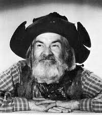
Gabby Hayes
Most everyone in my generation idolized Roy Rogers and Dale Evans and got to know his many sidekicks who provided comic relief; Pat Brady, who drove a Jeep named ‘Nellybelle’, Andy Devine and George ‘Gabby’ Hayes, who both had voices that made you wince and faces for radio. We also became acquainted with Roy’s faithful German Shepard, Bullet. Rogers and his entourage appeared in over 100 films and had top rated radio and TV shows in the 40s and 50s.
Roy was born Leonard Slye (a name Hollywood had to change!) in Ohio and quit high school at 15 to work in the family shoe factory. The family moved to California during the Great Depression where Roy worked driving truck and picking fruit. He was always interested in singing and yodeling and worked with several bands over the years until he and a friend formed a group that became the ‘Sons of the Pioneers’ and ultimately signed a record deal. In 1935, Roy’s good looks landed him his first bit part in a Gene Autry movie. Three years later, when Autry was demanding more money (probably saving up to buy the California Angels!) the lead part was offered to Roy and he was on his way to becoming a matinee idol.
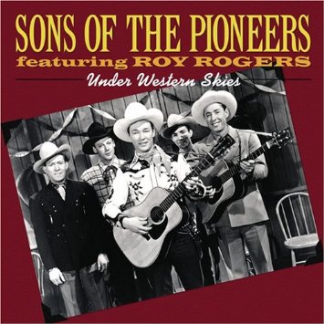 Roy always wore a white hat that never came off during a fight while he was knocking out the bad guys, in black hats, with one punch. Towards the end of each movie or tv/radio episode, after he’d righted all the wrongs, he would pick up his guitar and sing a song, often accompanied by Dale and his back-up group, The Sons of the Pioneers, whose songs can still be purchased on iTunes.
Dale was a story unto herself; born Francis Smith in Texas, she was married at 14 and divorced with a child at 16, yet continued to pursue her singing career. Her marriage to Roy, his second and her fourth, lasted 51 years, until his death. She wrote their theme song, Happy Trails.
He was dubbed, ‘King of the Cowboys’, she, ‘Queen of the West’.
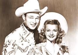
Roy Rogers & Dale Evans
Roy died in 1998 and Dale three years later. They are now both interned at the Sunset Hills Memorial Park . . . in Apple Valley.
If you’re ever passing by Apple Valley and want to visit the museum . . . the original Roy Rogers museum was erected in 1967 in an old bowling alley in Apple Valley, it moved to a bigger building in neighboring Victorville in 1976. To draw more people it moved again to Branson, Missouri in 2003, but eventually shut down for good, due to lack of interest, in 2009.
The passing of an era . . . a very good era indeed for those of us who were fortunate enough to have lived in it. Thank you Roy Rogers and Dale Evans, for all the Happy Trails.


")

")
")
")
")
")
")
")
")