The Inca Trail – Day 4 Machu Picchu

by Bob Sparrow

stones 3We had an early wake-up at 5:00 a.m. At breakfast we could see other groups in camp heading down to the trail and turning left toward Machu Picchu, when we got to the trail, Humberto turned right. We looked at each other quizzically, as we knew he knew that Machu Picchu was the other way, but we also knew that Humberto wasn’t lost, so we followed. After a fairly short hike, we came to a clearing and to a placed called Winaywayna. I’ll come back to explain more.

G killer

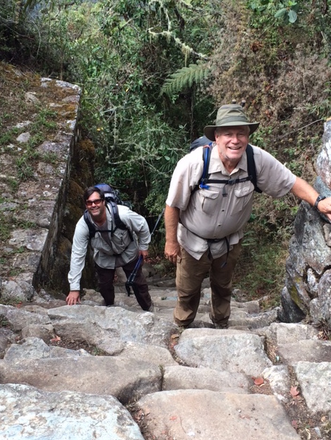
Pat and me on the ‘Gringo Killer’

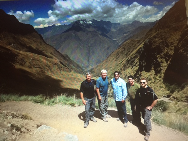
We turned around and headed for Machu Picchu, but just prior to getting there Humberto tells us to go ahead of him, that he wants us to experience this on our own. So we round the next bend in the trail and are confronted with what is known as ‘The Gringo Killer’. It is the trail, or more aptly a ladder, of granite stones going straight up that requires hand-over-hand climbing to scale them. About half way up we look back to see Humberto standing there with a big grin on his face.

Shortly after ‘The Gringo Killer’ we come to the Sun Gate, which is the unofficial entrance to Machu Picchu from the Inca Trail; we renamed it ‘Rain Gate’ since it had started to rain again. The Sun Gate is on a ridge above Machu Picchu and was built by the Incas in such a way that the sun would shine through a hole in the stone and onto Machu Picchu on December 21, their summer solstice that marks the half way point of their year.

sun gate

Sun (or Water) Gate

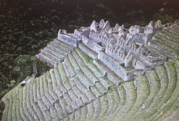
From the Sun Gate, for the first time, we see the vast expanse of Machu Picchu, the mountains that surround it and the incredible stonework that the Incas crafted. The many pictures of it that I’ve seen since booking this trip, and the many descriptions I’ve read, all pale in comparison to standing there and taking it all in. It is such an incredible work of architecture and art that it just boggles the mind to think about how it was all put together. I try to envision how it was back then, the movement and placement of the stones, the terracing of the steep mountain slopes for crop-growing, the creation of intricate irrigation systems for drinking, bathing and nurturing the crops. I try to envision the approximate 400 inhabitants going about their daily lives in this Andean paradise.
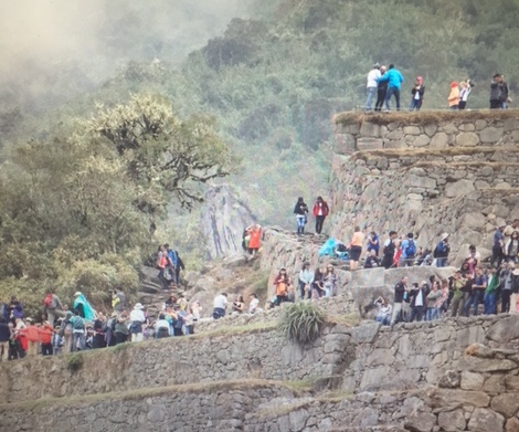
CRoWDS

‘Mucho’ Picchu

But it’s hard, when I look down and see hundreds of tourists milling around through the complex. Unfortunately we arrived on a Saturday and the place was shoulder-to-shoulder with people from all over the world, who had come early by train to see a sun rise over the Sun Gate on this rainy day. That’s not to say that it ruined our experience, it didn’t, it just colored it a little differently than we would have liked.

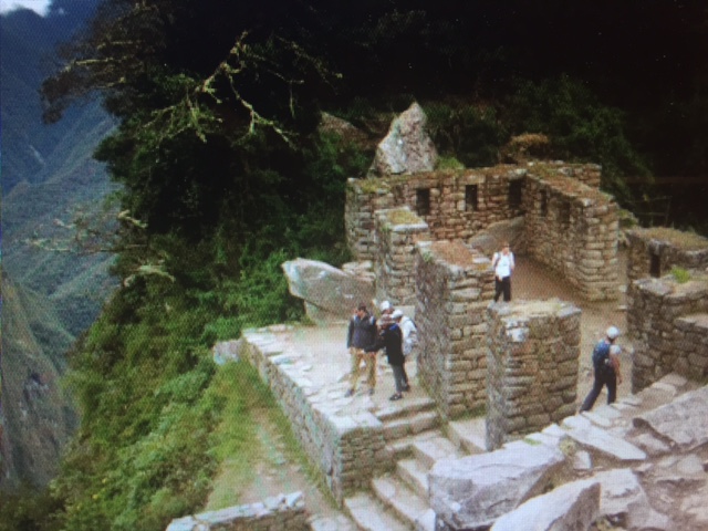
Back to Winaywayna – when we left camp and turned right, Humberto wanted us to experience something very special. As we came around the corner to Winaywayna (it means ‘forever young’), we all just stood there in awe and said, “Wow”. It is a complex similar to Machu Picchu, only much smaller – stone wall terraces, stone buildings, and irrigation systems that were still working, while several llama were grazing on the terraces. And on this beautiful mist-covered morning, we were the only ones there. The only ones there! We would appreciate that much more when when got to Machu Picchu.  We walked out on several terraces, examined the water features for irrigation and bathing and looked at the living quarters, all made of stone that will be there for centuries to come. The four of us talked about it later and concluded that being at Winaywayna that morning was on all of our ‘top 2-3 highlights’ of the trip. I can’t speak for the others, but for me it was somehow an incredibly spiritual experience.

WW

Winawayna

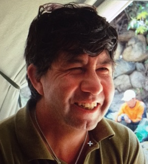
We spent about three hours touring through Machu Picchu as Humberto gave us vivid and detailed accounts of Incan life here during the 15th century. I mentioned earlier that your guide can make or break your trip – we were extremely lucky to have someone with the knowledge and wisdom of Humberto – he made our trip!

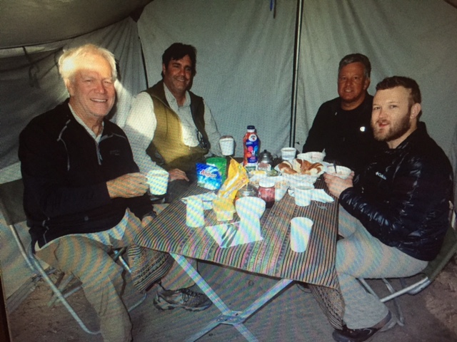
From Machu Picchu we take a train into the Sacred Valley where we meet our van that takes us to the Sol & Luna Hotel, where we have our first shower in four days – you can imagine that our van didn’t exactly smell like a bouquet of roses! We had dinner at the hotel and, exhausted from four exhilarating days in the Andes, we were all anxious to get into a real bed.

The next day we went into Cusco for our last day in Peru. As our van came through the hills over-looking Cusco, we were reminded of the ever-present poverty that exists in this country. Ironically the homes on the hillside that have spectacular views of the city and the Andes, are the most impoverished, as the higher up on the hill a home is, the colder and windier it gets, and thus less desirable.

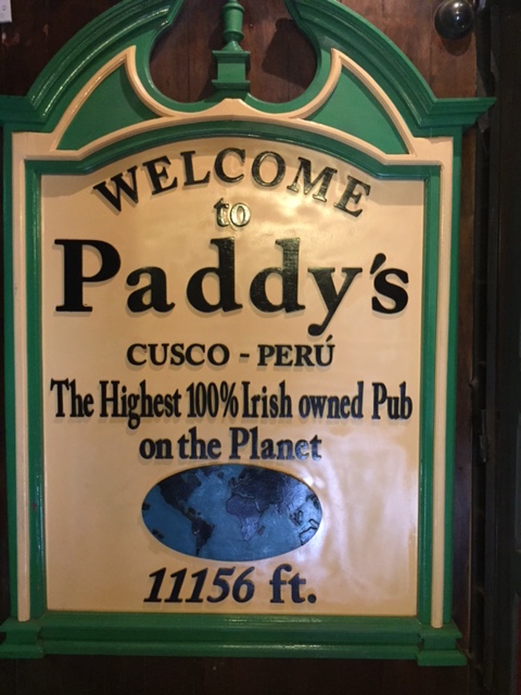
We knew we were ready to come home when we spent our last afternoon in Cusco in Paddy’s IrishMP best Pub, having a beer and a cheeseburger while watching the 49ers beat the Ravens.

It was an incredible adventure; one I’m glad I didn’t wait too much longer to do.  Thank you to Patrick, Steven and Graydon for sharing this awesome, life-time experience and thanks to those of you who followed along vicariously; as you know, you’re the reason I do this crazy stuff.

The Inca Trail Hike – Days 2-3

by Bob Sparrow

Day 2

DWP

Dead Woman’s Pass

If I just had one word to describe the hike on Day 2 it would be, ‘hard’; if I had two words, it would be ‘very hard’, if I had more than that this blog wouldn’t be rated PG.  It is a ball-buster! It’s only about 6 miles, but it all up – very up. Patrick calculated that today’s hike is like climbing the stairs of a 30 story building . . . 10 times. We are on the trail at 7:30 and Humberto reminds us to take tiny steps to keep the heart rate down. He reminds us that there is no hurry to get to the next camp, that there is nothing to do once you get there anyway, so take our time.

The first section is 4 miles, all up, going from just under 10,000 feet elevation to just under 14,000 feet elevation at the summit at ‘Dead Woman’s Pass’ – so called because the mountains at the summit resemble a woman lying down. No women have died there to my knowledge. While we are on the subject of women, we saw a lot of them on the trail, so I asked Humberto if there were typically more women than men on the trail. He said yes.  Did you hear that Dorie Riddle?

Without a doubt there is a certain amount of euphoria when you hit Dead Woman’s Pass, but it is short-lived as the next two hours will be spent pounding down the granite stone steps – not an exercise that is particularly good for my ‘vintage’ knees. After a ‘mere’ 6 miles, we make camp at 12,000 feet, and retire early to another evening of partial sleep.

Day 3

Misty summit

Heading into the ‘rain forest’

As we awake on Day 3, there is a certain amount of relief that we had survived Day 2, but Day 3 is no walk in the park; in fact today it is rainy and cold much of the day, so I guess you could call it a walk in the parka. The day starts with another up-hill climb that lasts about two hours and then levels, which in Incan means up and down. Rain, fog, clouds and mist greet us at the summit as we now entered a more ‘rain forest’ environment – complete with rain!  As miserable as the weather sounds, we all agreed that these conditions added an almost mystical aura to the trek.

When we stopped for lunch, it was cold and windy and the soup the cooks had prepared really tasted good. We actually had soup for almost every lunch and dinner and, I know we were always tired and hungry at mealtime, but the cooks did a great job of offering a good variety of food, which always included cocoa leaf tea – I think I’m hooked; I need to find a dealer in the U.S.!  We continued on until we stopped to make camp (OK, the porters had already gone ahead and made camp for us!) and had covered nearly 12 miles. Coupled with Day 2, it was two really challenging days of hiking – without much sleep.

Since this would be our last evening on the trail, we had a little farewell ceremony with the staff, where they presented us with a bottle of wine (our first alcohol in three days, although we did have the cocoa leaves going for us), and we presented them with their tips. We wanted to present the ‘rookie’ porter with a little higher tip, as he was the one who had to carry the ‘potty’ and the gas butane tank (a bad combination), but we were told that would just spoil him and he’d always want to do that. The cook also ‘baked’ us a cake – I don’t know how he did that out in the wilderness with no oven, but it tasted pretty good!

We were excited that we would finally get to see Machu Picchu in the morning and we were also very excited at the thought of taking a hot shower and sleeping in a real bed tomorrow night!

Next: The Inca Trail – Day 4 to Machu Picchu


Moray, Salt Mines and On to the Inca Trail

by Bob Sparrow

Humberto

Inca Trail guide, Humberto

After a good night’s sleep, we wake up Tuesday and meet our guide, Humberto, at our hotel. Your guide can make or break your trip – Humberto made it, in spades! He is 54 years old, head of the Inca Trail Guide Association and has made nearly 1100 trips (yes, 1100!) up the Inca Trail to Machu Picchu; we felt fairly confident that we weren’t going to get lost. Aside from his technical skills, he had an engaging personality, and easy smile and a great sense of humor; he fit right in to our group.

Moray

Moray

Today we drive out of the city to our first stop, Moray. It is best described as an Incan agricultural laboratory. From the picture it looks like it’s just a hole in the ground with some circles dug out of it. It is that, but the location is well chosen for it topography and rain fall and the circles are intricately scribed at precise levels creating various microclimates so that a variety of vegetables can be planted to see which ones thrive best under which condition. Ingenious!

Our next stop is the salt mines. On the way we are surprised to see prickly pear cactus and agave lining the road – very desert-like. Humberto tells us that the road to the salt mines is “lined with tequila” and with the salt from the mines, all we’d need is a lime and we’d have the start of a great margarita!

salt mines

Incan Salt Mines

The salt mines were originally created by the Incas and have been a source of salt and employment ever since. We were able to actually walk through the sections of salt and see how the natural salt water coming from inside the mountain collected and produced literally tons of salt each year.

We hiked about 5 miles down the hill to our van; I think it was Humberto’s way of giving us a little test run – we all did fine; it was mostly down hill and we were starting to get acclimated to the thin air. By late afternoon we were back at our hotel for a little rest before we went to dinner at a restaurant that Humberto had recommended.  We had a glass of wine to celebrate starting the hike in the morning and to the fact that we would not have anymore wine for the next four days!

The Inca Trail – Day 1

4 start

Me, Steven, Graydon & Patrick at the start of the hike

Our ‘team’ consists of the four hikers, Patrick Michael, who is not only a hiking buddy and a neighbor, but a good friend, who reignited my interest in hiking when we hiked Mt. Whitney several years back.  We have done numerous hikes together since then including Half Dome and the Himalayas. Steven Bernardy, who I just met while training for this hike, is a successful financial planner, who’s full of life and rarely at a loss for words – good hiking companion, as there is never a dull moment. Graydon Bernardy, Steven’s 22 year old son, is a recent graduate from the University of San Francisco and an intelligent and insightful young man; and me, AND our guide, Humberto, a cook, an assistant cook and 8 porters; so yes, a cast of 15 set out on Wednesday morning.

Meal tent

Meal tent

Today’s hike will be approximately 7-8 miles that are fairly level – actually there is no ‘level’ in the Andes – ‘fairly level’ just means not crazy up hill. Our porters and cooks take off a little after we do, but quickly pass us like we were standing still. We will see them about 3-4 hours later when they have set up our ‘meal tent’ and the ‘kitchen tent’, had lunch themselves, then cooked and served our lunch. Once we finish, we head out on the trail again, while they break down the tents, clean up the pot, pans, dishes, stove, pack them up and then we see them passing us on the trail again to set up for dinner. This is how it works for the whole trip, except when they get to the spot where we’re spending the night, they also sent up our sleeping tents and the ‘potty tent’. Patrick even saw a porter carrying a woman ‘piggyback’ up the trail – that’s above and beyond the call of duty! These guys are truly amazing athletes and just great people.

cocoa leaves

Cocoa leaves – illegal in the U.S.

Due to the barren topography, low clouds and mist, there is not a lot of great sights along the trail, but it’s just as well, with our heads down, our brains oxygen-deprived and our mouths full of cocoa leaves, we probably couldn’t see anything even if there was anything to see.  But the trail has history and it is a true hiking test. Oh, the cocoa leaves?  They are offered to us to chew on, put in our tea or do with as we wish, as they help the body remain strong under stressful hiking conditions. These are the same leaves from which cocaine is made, and are against the law to grow or import into the U.S. The reality is they’re really safe and I could hardly feel the affect of them, except that one time I saw a psychedelic llama dancing with a lavender alpaca.

tent

Our luxury suites

We cover about 7.5 miles before we reached our ‘home’ for the night, which is a two-man tent on the ground; our shower is a bowl of warm water and a paper towel and our bathroom is a small tent around a seat with a bag under it – not exactly the Ritz Carlton. Sleep, even after a long, hard day of hiking, comes begrudgingly if at all.

Next: The Inca Trail – Days 2-3


The Inca Trail to Machu Picchu – Floating Down to Peru

by Bob Sparrow

“Come fly with me, let’s float down to Peru

In Llama land there’s a one-man band, who will toot his flute for you”

llama2

———“Float this!”———-

 Frank Sinatra’s Come Fly With Me has been playing in my brain throughout my flight to ‘Llama land’. Frank may have ‘floated’ down to Peru, but I’d hardly describe a cramped airline seat in the back of the plane, on a full flight, with turbulence over the Andes on a ‘red eye’ then sitting in the Lima airport waiting for our connecting flight to Cusco, as ‘floating’. We didn’t see any one-man bands either, unless you count the guy sitting next to me on the plane who had beans for lunch. I’m thinking Frank traveled First Class. After 17 hours of travel and layover, our flight arrived in Cusco at 7:30 a.m. Monday morning.  Sleep-deprived, jet-lagged and disorientated, we half expect to get from the airport to our hotel on a flatbed truck filled with pigs and goats. We were wrong – the truck was filled with Llamas and chickens. Nah, just kidding, our Global Basecamp guide was there to greet us and rushed us off to Hotel Midori in the heart of Cusco for a much-needed rest.

cusco

Cusco

We’d all been watching the weather Cusco and Machu Picchu from home over the last 2-3 weeks and it showed nothing but rain nearly every day. I figured that could be a good thing, in that it’s getting the rain out of its system before we get there; or it could be a bad thing in that it was a signal of an early start to the rainy season. We are in luck, our first day is clear, mild and in the mid-70s.

The Midori, is strategically located in the center of town, so after a little rest, we head out on foot to explore the city. But wait; did we forget something? Yes . . . air!!! The first thing we all noticed was that we couldn’t breathe! After walking just a few feet on level ground, I was panting and puffing like a lizard on a hot rock. We were quickly reminded that Cusco is over 11,000 feet in elevation – the ‘two miles high city’! In spite of its rare air, we managed to make our way through much of this streets of cuscogreat city. A majority of the economy of this city is based on tourism and thus it is filled with many charming hotels, restaurants of every description, most serving local cuisine to include llama, guinea pig and a hundred varieties of potatoes. Being the jump off point for trips to Machu Picchu, there is also a lot of trekking outfitter stores and of course your requisite t-shirt shops and street vendors plying everything from alpaca sweaters to hand carved gourds. But the best part of Cusco is its people. As a group they are very friendly, hard working, nice looking and always seem to have smile on their face; they were sincerely a joy to be around.

We visited a number of museums and churches and saw some great examples of Inca stonework that, while the more ‘modern’ Spanish buildings crumbled to the ground during three major earthquakes in Cusco, the Inca foundations of mortar-less, tight fitting stone, survived them all with flying colors. This stonework is truly amazing; you couldn’t get a razor blade in the space between these giant stones and they did it all with fairly primitive tools, or with the help of ancient aliens. Amazing!

It was only a matter of time before we found what I’ve sought out in almost every city I’ve visited . . . Paddy'san Irish Pub. We stopped for lunch at Paddy’s Irish Pub, which claims to be the highest Irish Pub in the world at 11,156 feet. Even though we had to climb a flight of stairs to get there (which was no easy task!), we enjoyed a great lunch and a cold one before we continued our tour of the city.

We opted for an early dinner at a nice, second story restaurant which over looked the main town square, where a band and group of young school children were celebrating something – it was a beautiful, but short evening, as we had been going fairly strong for the last 30 hours, and we needed our rest and our bodies to acclimate to this rarified air if we expected to hike the Inca Trail in two days.  As a matter of fact, I’m getting winded just writing this, so time for a break.

Next: Outside of Cusco and Hitting the Trail


THE DROUGHT AND THE JUNE LAKE LOOP

By Suzanne Sparrow Watson

mammothYes, it’s me again this week.  As you read this my brother is hiking Machu Picchu.  Which means he has no access to the internet.  This could be my opportunity to write something really awful about him, except that he’s a really good guy and right now I’m just hoping he has a really great time.  So instead, I’ll write about my recent trip to June Lake Loop and the ravages of the California drought.

For those of you who live in Southern California you are probably familiar with Mammoth Lakes, a renowned ski town and home of several Olympians.  It is a place that my husband has visited yearly since 1960 and we have been going there together since the mid-80’s.  As someone who grew up going to Lake Tahoe,  I always considered “the Lake” to be the most beautiful mountain retreat in the Sierras.  And truly, it IS spectacular. But there is something about the eastern escarpment of the Sierras around Mammoth Lakes that takes your breath away.  Rather than the gently sloping foothills that you see on the western side, the eastern stretch juts out at a sharp angle from the flat terrain.  Mammoth is also higher than Tahoe – the town sits at about 7800 feet and the top of the mountain (which I have been crazy enough to ski down) is at a staggering 11,000 ft.

The Aptly named "Oh" Ridge

The Aptly named “Oh” Ridge

When we travel there in the summer we usually make a point of driving the June Lake Loop, a five-mile stretch of Highway 158 that is approximately mid-way between Mammoth Lakes and Lee Vining.  The loop is literally a horseshoe-shaped road that sits between the eastern Sierras and the four lakes that rim the road: June, Gull, Silver and Grant. Six hundred and twenty-nine brave souls live along the shores of the loop as permanent residents, but the population swells to thousands during the summer and fall.  It is the ideal place for fisherman, backpackers and day hikers.  They also have added a new spa which is attractive to people like me who leave their siblings to do the “outdoor” stuff.  This year we made the trip again, partly to see how the drought had affected one of our favorite spots.  As we entered Highway 158 coming north from Mammoth Lakes the first site we came is Oh! Ridge.  As you can see from the picture (right) the ridge earned its name.  I can’t remember a time when upon coming to that point I didn’t say “OH!”.  This picture was taken from my car window as my husband was trying to avoid the jerk driver behind us who was tailgating.  So you can imagine just how gorgeous the picture would be if we had actually stopped.  Still, you get the idea.  Although we had been reading a lot about the California drought, and June Lake was definitely down from previous years, it still looked pretty good.  A bit past the ridge we entered the village of June Lake, the hub of the loop.  It is where most of the population lives, where the businesses are and is adjacent to the June Mountain ski area, a favorite of locals.  There are several good little motels and best of all, an ice cream store.

Gull Lake is a litter harder to see from the roadway but sports its own marina and is a great place for fishing.  A mile down the road is the beautiful Silver Lake.  It is situated such that it often has a reflection of the mountain on the water and is another breathtaking site.  Unfortunately we were there on a cloudy day so it wasn’t showing its best side to us but is beautiful none the less.  I always have a soft spot in my heart for the only business on the lake, the Silver Lake Resort and Café.  It has been in business since the 1920’s, making it one of the oldest recreation resorts in the Sierras.  Make no mistake, “resort” is stretching the term a bit.  It is the type of place that sells everything from tee shirts to fishing lures at the check-out counter.  But back in the late 80’s when we embarked on this trip I had had a few too many…coffees.  There wasn’t a proprietor in June Lake who would let me use a restroom.  But the kind owners of the Silver Lake Resort saved the day, and my bladder, and I will always be grateful.  Again, Silver Lake looked a bit recessed but not alarmingly so.

The depleted Grant Lake

The depleted Grant Lake

The last lake on the loop is Grant Lake, by far the largest of the four.  It serves as part of the Los Angeles Aqueduct so its level is constantly changing depending on how much water is being sucked out of it to head south.  Given the relatively good conditions at June and Silver Lakes we were not prepared for what we saw as we rounded the bend and Grant came into view.  While the photo I took (left) shows some beautiful colors, I quickly realized that I was looking at brush and other flora that used to be underwater.  Trucks and boats were parked on its shores where water used to be.    The marina, which previously sat at the center point of the shoreline is now at its most northern edge.  After spending much of our summer traveling California this was the first time we came face to face with the ravages of the drought.

Snow!

Snow in October!

We left “the Loop” and headed north to Lee Vining to see what Mono Lake looked like.  In past years when the water is low the two islands in the middle of the lake seem to be attached.  As Mono came into view it was clear that not only were the two islands seemingly connected, you could walk from one to the other without so much as getting your toes wet.  We headed back to Mammoth Lakes very depressed by what we had seen.  I’m not sure there’s enough water conservation techniques in the world that can bring Grant and Mono Lakes back up to normal levels.  The weather nerds are predicting a record-breaking El Nino this year and I sure hope they are right.  I won’t mind cancelling a few plans if it means the Sierras get dumped with snow. 

The next day, perhaps a portent of things to come, it started to rain.  The following morning we awoke to snow on the mountaintops.  We can only hope there is much more on the way.

LIVING WITH A NAG

My very first nag

My very first nag

By Suzanne Sparrow Watson

I’ve been thinking about my brother this past weekend, what with him scaling Machu Picchu and all.  We both like to walk, although putting our “walking” in the same category is like comparing Kohl’s to Nordstrom.  He goes for the big stuff (who can forget his wonderful posts from the Himalayas?) while I’m a bit more lazy down to earth.  I huff and puff riding up an escalator, so climbing mountains is definitely not my thing.  But for the past five years I have worn, in succession, an Omron pedometer, Jawbone Up band and a Fitbit Charge.  My goal with each of them is to walk 10,000 steps per day, which works out to about 4.5 miles.  Although the technology has varied among these devices, they do have one thing in common: they all nag.  There is nothing worse than checking my Fitbit mid-day only to discover that I’ve walked a measly 4500 steps.  How can I sit down to read or knit or watch a movie when “the nag” on my wrist is shouting “Get Off Your Ass!”?  Okay, maybe it isn’t really shouting at me but that’s what I hear in my head.  In general, it’s a good motivator.   I tell myself that by walking extra steps I am able to indulge in more cake, although I’m not sure that’s the intent.  The other day I got to wondering what is so magical about the 10,000 step standard.  The results of my research were surprising – and ultimately, depressing.  So, I thought, why not share it with our readers so I won’t suffer alone?

The beginning of the craze

The beginning of the      craze

It turns out that the origin of 10,000 steps per day as a health guideline started in Japan in the 1960’s, right around the time of the 1964 Tokyo Olympics.  Apparently walking became a national “sport”, perhaps to show the world how athletic and health conscious they were.  At the time Japan was blessedly free of the U.S.-based fast food joints.  They consumed much less animal fat and fewer calories overall than most nations.  Even today, with the advent of a McDonald’s on the Ginza, the Japanese eat a healthier diet than we do;  I think it’s safe to say that Japanese television doesn’t advertise Triple Bacon Chili Cheese Deep Fried Taco Burgers.    Anyway…back to the 10,000 steps.  With the advent of the walking clubs a daily walking goal was proposed as a marketing gimmick by a company that invented a pedometer, or as it’s known there, a man-po-kei. “Man” stands for ‘10,000,’ “po” stands for ‘step,’ and “kei” stands for ‘meter’. Ten thousand, it turns out, is a very auspicious number in Japanese culture so people thought it good luck to walk that many steps.  For the Japanese, who consumed about 2600 calories per day back then, it magically resulted in improved overall health and weight loss.

Probably should be illegal in 47 states

Probably should be illegal in 47 states

The 10,000 step craze started picking up steam in the U.S. about 20 years ago when that pesky Surgeon General said that, as a nation, we were becoming too fat.  That led to the “30 minutes of exercise a day” suggestion and then it was a quick downhill slide to the 10,000 steps phenomenon.  Americans started walking more, buying pedometers, and expecting to lose weight.  But there was one snag: the average American consumes about 3800 calories every day, much of them unhealthy calories.  Which leads one quickly to the conclusion that if we’re consuming 30% more calories than the Japanese did in 1964, then we need to commensurately increase the number of steps we walk if we want the same results.  I consulted with the fitness instructor at our club, hoping she could make sense of it.  Alas, when I told her I was walking 10,000 steps a day she said, “Well, that’s good. But if you really want to lose weight, you’re going to have to walk at least 13,000.”

I can tell you right now, I’m not going to walk 13,000 steps per day.  And I’m going to continue to eat cake.  I’d rather be nagged by the device on my wrist than be like all those people on the Titanic whose last thoughts were “Damn!  I wish I hadn’t passed on dessert.”